Footpaths

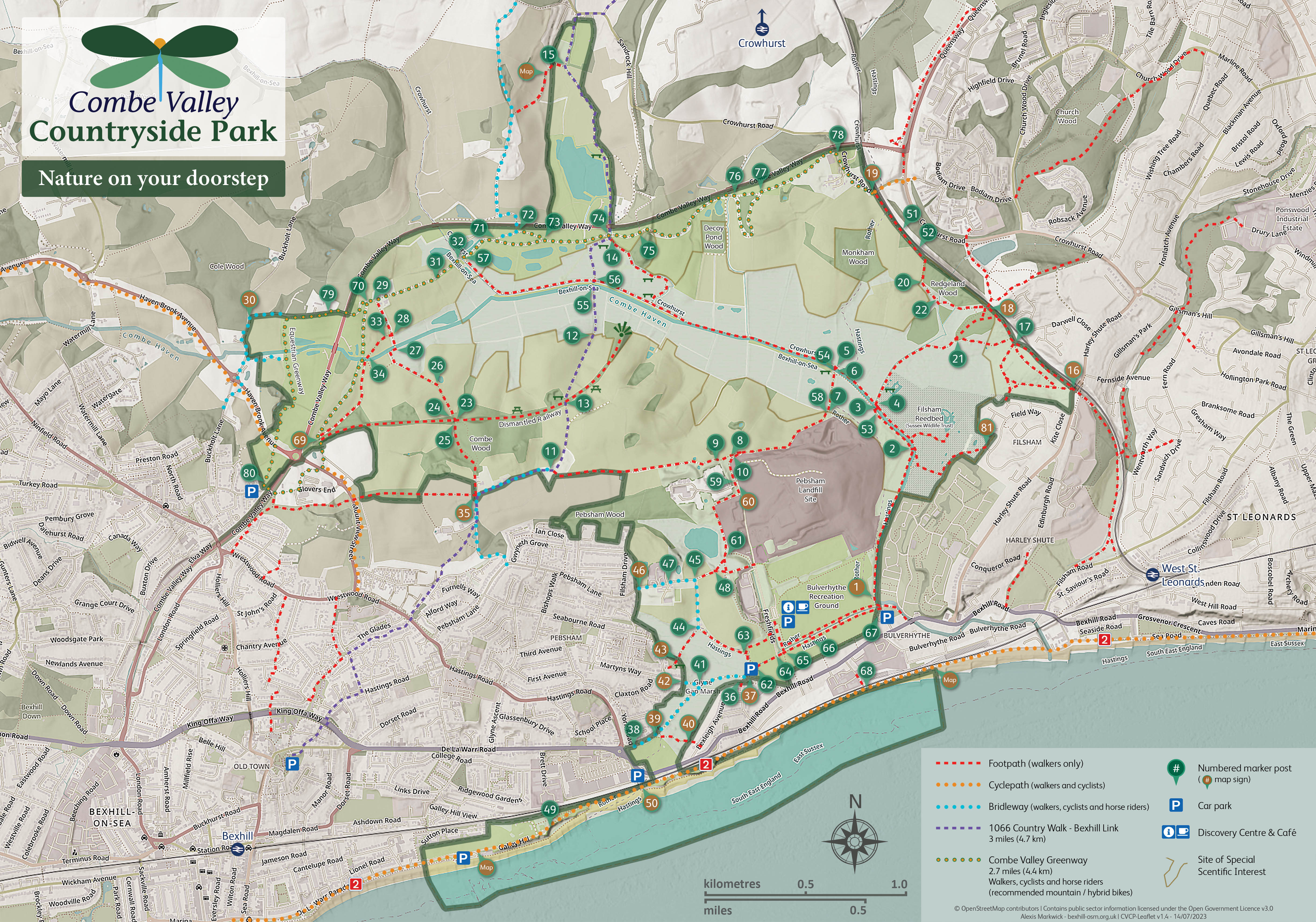
The map shown above is taken from our 2022 leaflet, ‘Nature On Your Doorstep’. The leaflet is designed to be printed at A3 size but should still be readable at A4. Full size printed copies are available from the Discovery Centre (Freshfields, opposite the Waste Disposal Centre) and other places such as Bexhill Museum, and the Oceanside Cafe.
Details of the park are also shown on the Bexhill section of OpenStreetMap.
A very useful app for your phone is Organic Maps which can be used off-line and has all the paths plus the numbered marker posts on when zoomed in.
Footpath Problems
The ESCC website has Right of Way maps which shows which paths they are responsible for. If you notice any problems along these paths which make walking them difficult (fallen trees, encroaching brambles or nettles, broken gates or bridges) please report them on their website.
Problems with other footpaths (not public rights of way) should be reported to Friends of Combe Valley
The Combe Valley Greenway
The Combe Valley Greenway, a route for pedestrians, cyclists and horses, runs all the way from Sidley in the west to Crowhurst Road near Upper Wilting Farm in the east and mostly runs just east and south of the new link road, Combe Valley Way. In the East it will eventually link up with the proposed Hastings Greenway.
Greenway Access from Sidley
From the Sidley car park shown on the map, at the end of Glovers Lane (just the end of the lane really), there is a permissive equestrian route (part of the Greenway) running North to the North Bexhill Access Road (NBAR) where it links with a footpath/cycleway which follows the NBAR to the North-West. The Equestrian route then continues North via a ford to where it joins Buckholt Lane just West of the bridge across Combe Valley Way between marker posts MP30 and MP29. The ford can be impassable to walkers during times of flood.
For cyclists and pedestrians a better route crosses the bridge towards the business park and turns left to skirt the car park and down to Mount View Street. At the moment there is a short diversion here because of construction work. Crossing the road the path goes further downhill to the bridge under the disused railway track. Just before the bridge there are steps up to the disused railway track and immediately under the bridge there is a footpath to the right that it is best to avoid as it gets very muddy. Ahead is the Combe Valley Greenway which provides a dry route for pedestrians and cyclists running up the eastern side of the new road to where it meets Buckholt Lane. The Greenway then follows the existing path via Actons Farm as far as MP57 and then continues fairly close to the new road passing MP74 at the junction with the "1066 Country Walk – Bexhill Link" and on to Upper Wilting Farm and MP19.
Greenway Access from Upper Wilting Farm
The Combe Valley Greenway starts immediately west of the railway bridge on Crowhurst Road, which is controlled by traffic lights. It goes north past the farm and then west along the valley until it gets to Actons Farm. About 50 yards west of Actons Farm the cycle/pedestrian path goes off to the left. The equestrian path continues along Buckholt Lane, across a bridge over the link road, and then leaves the lane to go via the ford to the NBAR and on to Glovers Lane.
Possible flooding during the winter
Much of the Country Park is a wetland habitat so during the wettest months of the winter some paths in the central part of the valley, particularly the 1066 country path, become flooded and therefore impassable. Some others get very muddy in places so good boots are essential.

