Archaeology of the Combe Valley
Fossils from about 160 million years ago have been found in the cliffs at Glyne Gap. Dinosaurs were also here in that period and remains have been found in the area, many of Iguanodon. Dinosaur footprints can also be found among the rocks at low tide.
Pre-historic Settlements
Archaeological finds show that man has been living in the area since the end of the Ice Age, some 12,000 years ago. At that time the sea level was much lower and Britain was still connected to the rest of the European land mass. The valley carved out by the ice flows was deeper than it is today, but as the Earth warmed up during the period between 10,000 and 4,000 BC the sea level rose dramatically cutting us off from mainland Europe and creating a coast line similar to that we have now. Initially the valley would have been flooded by the rising sea, but over time it has gradually silted up with layers of clay, peat and alluvium giving us the relatively flat marshy valley we see today. The valley would have continued out into what is now the sea and the remnants of a submerged forest off Bulverhythe Beach, which has been dated to about 2000 BC, lies within the silt that filled the valley. It was in this area that the Amsterdam was wrecked in 1749 (see below) and sank into the mud.
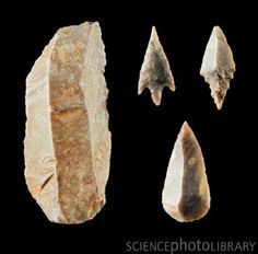
Evidence of the earliest settlers, mainly flint tools, has been found several metres below today’s surface. The different flint tools found, axes, arrow and spear heads and various blades show that man not only hunted in the area but had small settlements in the valley. There are also remains of pits and fireplaces.
Bronze Age settlements were probably more established with evidence of wooden structures, field systems and droveways. Numerous arrowheads from this period have been found along with a rare archer’s wrist guard.
Near Upper Wilting Farm there is clear evidence of several late iron-age bloomery furnaces with further development during the period of Roman occupation. Associated with this were remains of Roman buildings and enclosures. Then in Saxon times Upper Wilting was a manor and corn-drying ovens have been found and dated to the 7th or 8th century AD.
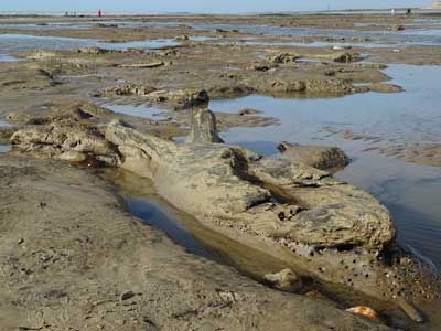
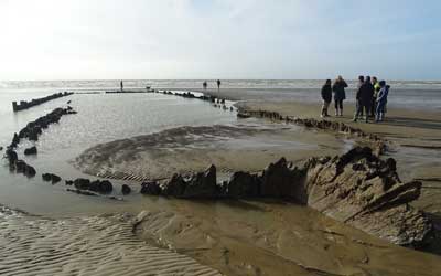
The Wreck of the Amsterdam
The Amsterdam was a cargo ship built for the Dutch East India Company to carry people, supplies and money to the East Indies and return with purchased goods such as spices, fabrics and china. Its maiden voyage was to have been to Java, via the Cape. However, after two false starts because of bad weather, she finally set sail on 8 January 1749, but got no further than Beachy Head tacking into a strong westerly storm while a number of the crew died of the plague. A mutiny broke out, the rudder broke and the ship was driven back and eventually beached at Bulverhythe on 26 January.
She began to sink into the mud and as the tide went out the crew clambered down the sides of the ship and were taken to safety in Hastings. Some of the cargo was taken into safe-keeping, some was looted by local smugglers and much of it still remains in the hull.
In just a few months it sank about 8 metres and, although the top section has rotted away, two thirds of the hull along with its contents still remains preserved in the mud. It survives as the most intact East Indiaman in the world.
During the 1980s major excavations were carried out on the wreck and numerous artefacts were recovered, many of which are now housed in the Hastings Shipwreck Museum.
A replica of the Amsterdam was built on the late 1980s and it is now moored in Amsterdam next to the Netherlands Maritime Museum, where it can be visited.
The wreck is protected and diving on it or removing timbers or artefacts is forbidden. The wreck may be visited at very low tides, but care should be taken because of the possibility of quicksand in the vicinity.
Pumping Station and Narrow-Gauge Tramway
The Hastings & St Leonards Waterworks had a pumping station in the Combe Haven Valley, the remains of which are hidden in the bushes about 150 yards west of marker post 56. Pumping Station No. 5 (Crowhurst) was originally a temporary wooden structure built in 1892 to house a steam engine to drive pumps extracting water from a 100 feet deep borehole. A 6 inch gravity main then took 116,000 gallons per day downstream for 1½ miles to No. 4 Station (Filsham) off Bexhill Road (near marker post 1).
The pumps were steam driven and coal was moved from Adams Farm on a 500 yard long 18 inch narrow gauge service tramway, using a hand-operated truck. The truck is believed to be preserved at Tinkers Park in Hadlow Down (www.tinkerspark.com). When the tramway was cut off by flooding, coal was sent up the Combe Haven by barge!
By 1908 it was realised that a permanent solution was needed and in about 1912 a brick structure was built to house both the existing and some additional equipment. It remained in use until about 1950 and a few years later was dismantled and the well capped.
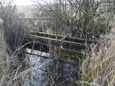
The new Link Road has obliterated the northern section of the tramway but 200 yards of line still run across a field south of the road and the 1066 footpath passes one end of it (between country park marker posts 14 and 56). The track is now hardly visible but is marked by a line of hedge running SW across the field towards the pumping station site near the Watermill Stream. Remains of one of the bridges over a ditch can still be seen as can the concrete base of the pumping station hidden in bushes along with a strange cast iron dome.
The Bexhill West Branch Line
The Bexhill West branch line was a short double-track branch line running from the Hastings Line at Crowhurst, via a station at Sidley to a terminus at Bexhill West. It was built by the Crowhurst, Sidley & Bexhill Railway, opened on 1 June 1902 and closed under the Beeching Axe on 15 June 1964.
About a mile of the trackway still exists within the park, running east-west along the high ground south of the river. The rails are long gone and the track now provides a very pleasant wooded walk with views across the valley. It has been declared a Site of Nature Conservation Importance (SNCI).
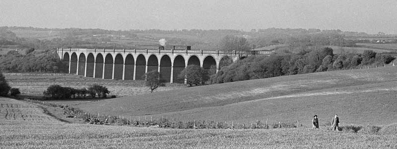
The largest structure on the line was the Combe Haven Viaduct which was 380 metres long and more than 20 metres high, with seventeen arches. Over 9 million bricks were used in the construction of the viaduct, supported on concrete block foundations. Following the closure of the line, it was proposed to demolish the viaduct. Local residents were opposed to the plan but as no group was prepared to take on the huge maintenance costs the viaduct was demolished in May and June of 1969.
Boundary Markers
Administrative boundaries used to be marked by boundary markers, often stone but sometimes cast iron. Many have disappeared as roads have been widened and new buildings erected. However, some can still be found including a few in the Countryside Park.
Borough of Hastings and the Liberty of the Sluice at Pevensey
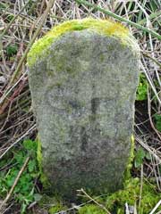
This is the boundary of the ancient Cinque Port of Hastings, established by Royal Charter in 1155.
In 1859 a local builder, Robert Burchell, signed a contract with the Corporation of Hastings to supply 60 stones to mark the boundary at a total cost of £33 15s. Made of York stone they were all inscribed C H with either a number or a letter beneath.
One of these stones can still be found a few yards north of MP37 (near Blackbrooks garden centre). The shape of the boundary here suggests that the marshy land between here and Pebsham was a harbour when the Cinque Ports were first established, but of course it has since silted up.
Another stone can be found near the petrol station at Glyne Gap.
Hastings Parliamentary Boundary
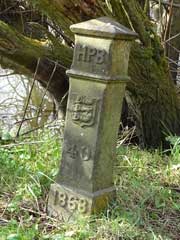
In 1868 41 cast iron boundary posts to mark the line of the Hastings Parliamentary Boundary were ordered from Alderton & Shrewsbury of Rock-a-Nore, Hastings at a cost of 22 shillings each (£1.10). There may have been a subsequent order as the 1873 6″ OS map shows the location of 45 posts.
Three posts can still be found within the park:
- HPB 39 – north of numbered park marker post MP4
- HPB 40 – near MP4
- HPB 41 – south of MP2 (east side of river)
Bexhill Borough
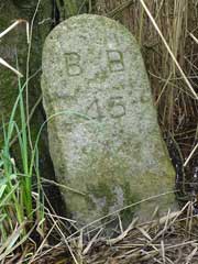
In 1909, after the incorporation of Bexhill Borough, 63 stones, inscribed BB with a number beneath, were positioned to mark the boundary of Bexhill. They cost 15 shillings each (75p).
Seven of them can still be found within the Country Park.
The stone pictured, inscribed BB 45, can be found almost in the drainage ditch between MP6 and MP7. The location of all the surviving stones can be found on the OSM map.
